
Last Friday (4/1/2011) I hiked part of the Maroon Bells Trail and was impressed by the improvements made by the GVM Trails Committee. Here’s a photo of my nephew’s foot next to one of the newly painted orange trail markers. Thanks, Trails Committee!
Last Friday (4/1/2011) I hiked part of the Maroon Bells Trail and was impressed by the improvements made by the GVM Trails Committee. Here’s a photo of my nephew’s foot next to one of the newly painted orange trail markers. Thanks, Trails Committee!
4/3/2011 In the previous post, Jim accessed the new Elkhorn Creek Trail from the Log Cabin Rd. I asked him if that was the same as the Boy Scout Rd. He emailed: “Log Cabin Road and Boy Scout Road (CR 68C), the same, although the latter name appears in Among These Hills: A History of Livermore, Colorado. The former stems from the Log Cabin Hotel, post office, and stage stop at the T juncture of CR 68C with the Red Feather Lakes Road (CR 74E). One can still see the concrete foundation of one of the buildings.” Thanks for the clarification and history lesson, Jim.
Jim sent additional information from that book on p. 26 : “The two-story [hotel] structure was originally built at the Ashley Grange, a place for training young English ‘remittance’ men how to become ranchers. It had been moved several miles north to this site in 1888 . . ..” Jim added “Such men appear to have been not a rarity in the Livermore region.”
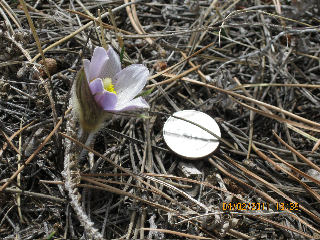
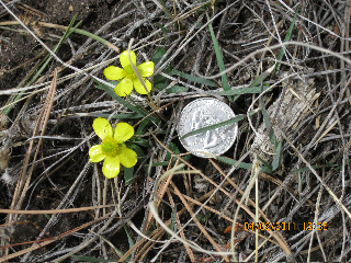
4/2/2011 Email from Jim E.: “What a memorable high-country hike early afternoon, on this balmy but windy day on the US Forest Service’s Elkhorn Creek Trail at ~8,000 ft. Its trailhead was renovated last year (I’d not even known it was there down the Log Cabin Road, which I’ve been on so many times). To my amazement I spotted the first flowers of the season! I could not believe it; had to go back to the truck for my digital camera.
3/15/2011 Email from Jim E.: “On listening to this feature on Living on Earth (KUNC at 5p), I thought this might be an interesting bit … It might pique someone’s interest in the handful (9 species) of lichens in the plant list for GVM. The genus Umbilicaria – on our list – is mentioned and illustrated.”
Thanks so much Jim, this is a fun piece, very interesting angle on studying old cemeteries in Massachusetts! I’ve pasted the link to the broadcast and also inserted the transcript with captions but not photos.
http://www.loe.org/shows/shows.html?programID=11-P13-00010#feature5
We Like Lichen
|
|
|
Anne Pringle at a local cemetery in Cambridge, MA. (EOL Learning and Education Group) |
|
|
|
Examining lichen on a gravestone. (EOL Learning and Education Group) |
|
|
|
Mycologist Benjamin Wolfe holds up a lichen called Umbilicaria mammulata. (EOL Learning and Education Group) |
|
|
|
Umbilicaria growing on a rock in Maine. (EOL Learning and Education Group) |
2/20/2011 Email from Jim E. “possibly worth a note in EcoBlog (a geologist, Jim Benedict, I knew used the technique to date Ute rock barriers above timberline to funnel elk or deer for the kill):
Benedict: http://www.jstor.org/pss/1551260” Thanks so much, Jim, for sending this information, quite fascinating!!
Here’s the link Jim sent General: http://en.wikipedia.org/wiki/Lichenometry and the first few sentences from WikiPedia…..

Picture of the Map lichen or Rhizocarpon geographicum, the most used lichen in lichenometry.
In archaeology, palaeontology, and geomorphology, lichenometry is a geomorphic method of geochronologic aging that uses lichen growth to determine the age of exposed rock: lichens are presumed to increase in size radially at specific rates as they grow. Measuring the diameter of the largest lichen of a species on a rock surface can therefore be used to determine the amount of time that the rock has been exposed. Lichen can be preserved on old rock faces for up to 10,000 years, providing the maximum age limit of the technique, though is most accurate (within 10% error) when applied to surfaces that have been exposed for less than 1000 years[1]. The use of lichenometry is of increased value for dating deposited surfaces over the past 500 years as radiocarbon dating techniques are less efficient over this period.[2] The most common lichen used for lichenometry are that of the genus Rhizocarpon, for example the species Rhizocarpon geographicum, and those of the genus Xanthoria.
Lichenometry can provide dates for glacial deposits in tundra environments, lake level changes, glacial moraines, trim lines, rockfalls, talus (scree) stabilization and former extent of permafrost or very persistent snow cover.
Among the potential problems of the technique are the difficulty of correctly identifying the species, delay between exposure and colonization, varying growth rates from region to region as well as the fact that growth rates are not always constant over time, dependence of the rate of growth upon substrate texture and composition, climate, and determining which lichen is the largest.
