6/27/09 : “Here are a few more pics from the Utah DER, maybe you could post a few on the blog you created? I also made a comment on our work there and my next project at Camp Gurnsey. Thanks for posting this stuff up!” Read the details from Paul’s email by clicking the link below his photos….

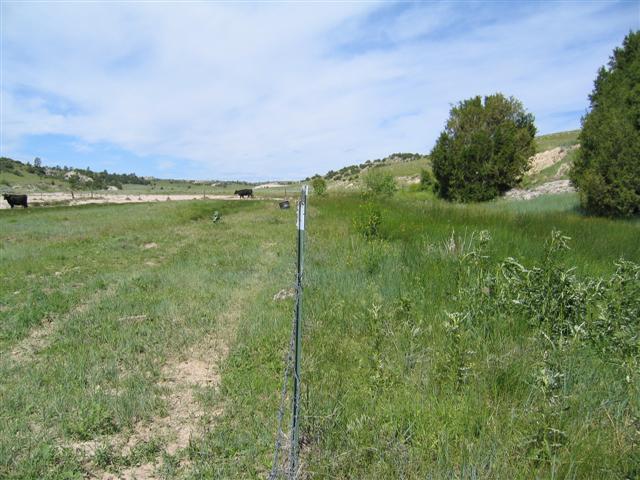


“You learn to appreciate the few flowering plants when your surrounded by a sea of brown vegetation and desert pavement! Our research was looking at the effects of sheep and cattle grazing on species diversity in the Great Basin desert ecosystem. The DER is composed of 20 fenced paddocks 1 mile long by 1/2 mile wide. In each paddock we quantified the vegetation in 54 -1 meter sq. quadrats. Quadrats were randomly located along transects we traversed up, then down, the paddock. This equated to about 6 miles of cross country walking per day. That is a lot of walking on sandy, rocky, gravelly terrain and the first 10 days (we worked straight through about 8-10 hours a day) was a little rough on the feet and back. By day 11, I was feeling pretty well conditioned, but that turned out to be the last day of our work!! The DER was fenced back in the 1930’s and each paddock has two small fenced exclosures inside that are un-grazed. Often, the fenced enclosures look markedly different than the grazed areas outside. Large mounds of cryptobiotic soil crust survive, as well as a diversity of species not found outside the exclosures. With an average of about 6″ of precipitation per year, it is a tough place to manage grazing, and this year has been exceedingly dry there, so no grazing is planned for the summer. In the next valley over, grazing is poorly mangaged and 100’s of square miles are practically devoid of vegetation today. Several different grazing regimes have been implemented to determine which are most suitable for the sustained forage production, without destroying the fragile desert ecosystem.
I have since returned and attended a wetlands delineation class in Boise, Idaho last week. My next assignment is a wetlands delineation over the whole of the 75,000 acre, Camp Guernsey Army National Guard Training Site. For all intensive purposes, the Army avoids training in or around these sensitive areas which make up a tiny fraction of the land area in this arid region. The real threat to wetland integrity at Camp Guernsey is from grazing cattle that manage to get through protective fences that were damaged by recent flash flood events. Cattle gravitate to wetlands like flys to carrion and there trampling in the saturated soils really mucks things up! Fortunately, these wetlands will recover rather quickly, owing to the abundance of moisture and unique requirements of wetland vegetation, that precludes exotic weed species from becoming established.”
Paul
Discover more from Glacier View Meadows Ecology
Subscribe to get the latest posts sent to your email.
